Tuesday, December 9, 2008

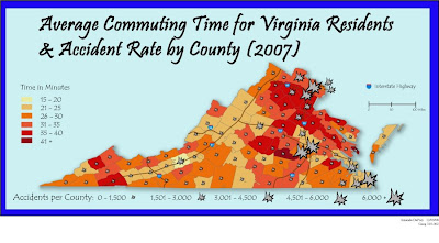
FINAL ^_^


This first link is to wtop traffic. always a good station to have on your presets.

Second is to Virginia Department of Transportation (VDOT). They do yearly reports on traffic flow, accident rates, etc.

Forbes article for the cities with the worst traffic.

The Commonwealth of Virginia home page. Look up information on cities and counties.

With such a high accident rate, your best bet is to have insurance.

Monday, December 8, 2008

in progresso part deux


Small version of final map to fit completely on screen:


*******


ok this one isnt so blinding! still in progress!

FINAL MAP....IN PROGRESS


just incase my flash drive crashes during the night. haha

but i'm not done yet.

Wednesday, November 19, 2008

LAB 10


i hope i did this right.


-Amanda

Tuesday, November 11, 2008

Friday, November 7, 2008

Monday, October 27, 2008

LAB 7 MAPS


LAB 7

There is a difference between each group. With equal interval there is 6 catagories and the gray varries alot more then in the natural break map where there are only 5 categories are there is a large number of states in the 28,000-35,999 category


-Amanda


Tuesday, October 21, 2008

choropleth map of viginia

http://www-nrd.nhtsa.dot.gov/departments/nrd-30/ncsa/STSI/51_VA/2006/fatal4.gif


this map is from the National Highway Traffic Safety Administration research and development.

Its an equal interval map so there are some data sets with no data in them.


Amanda

Tuesday, October 14, 2008

For All You Cool Cats, Tattoo/ Piercing Coupon

this has nothing to do with cartography class but i want to post it anyways.


yes, I have gotten tattooed there and yes, they are awesome. Tell them Angel sent you ^_^
- Amanda

Lab 6- Dots


This is my lab 6


i choose this data set because of:


-Amanda

Wednesday, October 8, 2008

Map of the Week - Dots


i choose this dot map of british columbia. its very blue. i would have like the background toned down just a bit.

Here is the link:
http://www.bcstats.gov.bc.ca/DATA/pop/maps/PopDot2001_1.gif


-Amanda

Monday, October 6, 2008

Wednesday, September 24, 2008

LAB 4


This Is Lab 4, Click Image for a Bigger View


-AMANDA


maps with text

the map i choose was a map of the united states

i choose it because it has various texts. the countries' text are bigger and are in magenta. It has a legend. the states are in all caps and the capital cities are in title case, and the map only points out the captials. The text for gulf of mexico shapes to the gulf of mexico. Water masses are also in blue. and are in a italic style text. Canada is spread out to cover the land mass of canada. It also has a scale.

Wednesday, September 17, 2008

Tuesday, September 16, 2008

Perspective Maps

The first map i found is a world map but its given in a perspective that you normally dont see. with asia on the left and america on the right.


Secondly, i thought this map was really wild because it is an antique polar map. it shows the perspective from the north and south pole, plus it has designs of sea adventures on the side.

Wednesday, September 10, 2008

Lab 1- Illustration of Sphere, Geoid, Ellipsoid and Natural Surface


This is my lab. ^_^

map for class on 9/9

I've chosen a map of locations of nuclear power plants in the United States. I dont think its the best map because it fails to include Alaska and Hawaii (but the ones that did include AK and HI were even more inadiquite plus those two states dont have power plants) but I like this one because it does outline the states, include degrees of latitude and longitude, and it points out major cities. This is a very basic map. it could not tell you how long these plants have been in operation, how big the plants are, or details like that.


-Amanda

Saturday, September 6, 2008

Links Post

The first site i chose was the class blog...

The second site i choose was the geography departmet's site...

The third site i choose was henry davis.com...it has some pretty interesting maps from various time periods.

The fourth site i choose was google earth...because google is awesome why not combine it with an awesome earth and have google earth...its double awesome.

The fourth site i choose was USGS (United States Geological Survey), its a government site. Find out what geographical news is going on in the world today along with maps.